Unveiling of the National Park Service Historic Trail Signs for the Camino Real de Tierra Adentro
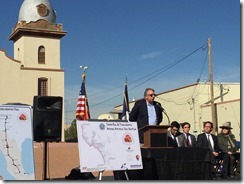
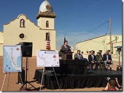
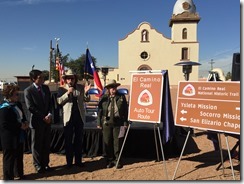
On Tuesday November 24 we unveiled the new National Park Services historic route signs and markers promoting the El Camino Real de Tierra Adentro National Historic Trail in El Paso County, Texas. The Trail is one of 20 national historic trails designated by Congress and maintained by the National Park Service; it is also the oldest Euro-American trade route ever established in the United States. The signage project, funded by the County of El Paso, will include the installation of over 100 signs along major roadways stretching from Anthony to San Elizario.
Work on developing the sign plan began in 2006 by the National Park Service, El Paso Community Foundation, El Paso County Historical Commission and the Texas Department of Transportation (TxDOT). The plan was presented to and adopted by the El Paso Metropolitan Planning Organization’s Transportation Policy Board in early 2013. However, the project remained unfunded until December 2014, when the El Paso County Commissioners Court voted unanimously to fund the project and to partner with the Camino Real Regional Mobility Authority for project management.
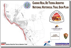
The markers will be installed along 45 miles of the following roadways: Doniphan Drive, Paisano Drive (Between Sunland Park Dr & Santa Fe St), the Cesar Chavez Border Highway section of Loop 375 and sections of Alameda Avenue and Socorro Road (the existing El Paso Mission Trail).
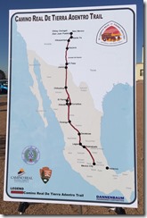
El Camino Real de Tierra Adentro, the Royal Road of the Interior, was designated by the United States Congress as a national historic trail in 2000 and is jointly administered by the National Park Service and the Bureau of Land Management. The entire trail spans over 1,000 miles and originates in Mexico City, Mexico; the nationally designated portion of the trail includes the 404 mile stretch from El Paso to present day Ohkay Owingeh, New Mexico (north of Santa Fe). For nearly 300 years the trail acted as the principal trade corridor for the growing southwest. Established in 1598, the trail facilitated further exploration and ultimately the settlement of the American Southwest. The trail is one of only 20 in the United States.
National Historic Trails are designated by the United States Congress to promote cultural, historical and open-space across the nation. Individuals may visit www.nps.gov/elca/ for more information on visiting the trail, including identifying the numerous cultural and historical assets that can be found along the trail.
Project to increase awareness of El Camino Real
Aaron Martinez, El Paso Times
County officials Tuesday unveiled the new signs that will be placed throughout the El Paso area as part of a $1.5 million effort to promote the historical route of El Camino Real de Tierra Adentro National Historic Trail, which explorer Don Juan de Oñate used in 1598 to explore the American Southwest.
“The history (of the trail) is very significant,” El Paso County Commissioner Vince Perez said. “When we talk about our nation’s history and the founding of our nation, the Pilgrims landed in Plymouth in 1622, Don Juan de Oñate began his exploration in 1598 and reached present day United States, present day San Elizario, in 1598 and moved northward and established the capital in Santa Fe.”
He added, “That is the significance of this trail. It is really the founding of the American Southwest, the first European exploration of the Southwest. It has tremendous history not only to our community, not only to the state, but to the nation as a whole. It is a true treasure that we have and one that I hope El Pasoans embrace. I hope this project promotes the trail and its significance through the signage.”
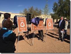
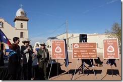
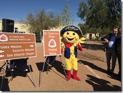
Perez, along with other city and county representatives, unveiled the three designs for the National Park Service Historic Trail Signs that will be placed along major roadways stretching from Anthony, Texas, to San Elizario, indicating the route of El Camino Real de Tierra Adentro National Historic Trail, the oldest Euro-American trade route ever established in the United States.
“Today was the culmination of an almost three-year effort to highlight the historic Camino Real trail,” Perez said. “It is one of only 20 trails designated by the U.S. Congress. It is the oldest Euro-American trade route in the Unites States and many people don’t know that it is right here in our backyard.”
In total, about 110 signs marking the historical trail will be installed along 45 miles of El Paso roadways including Doniphan Drive, Paisano Drive between Sunland Park Drive and Santa Fe Street, the César Chávez Border Highway section of Loop 375, sections of Alameda Avenue and Socorro Road, and areas of Interstate 10.
“This trail starts off in Mexico and it’s about 1,000 miles in its entirety with about 45 miles here in El Paso,” Perez said. “It starts off in Mexico City and then it first starts off here in San Elizario and continues onward and actually ends near Santa Fe. It was the route that Don Juan de Oñate took in 1598 when they first explored North America.”
The effort to get the signs made and installed on the trail was started in 2006 by the National Park Service, the El Paso Community Foundation, the El Paso County Historical Commission and the Texas Department of Transportation, officials said. The plan was then adopted in 2013 by the El Paso Metropolitan Planning Organization’s Transportation Policy Board, although the effort stalled after no funds were found for the project.
In December 2014, the El Paso County Commissioners Court voted to fund the project with the Camino Real Regional Mobility Authority managing the plan, Perez said.
The funding for the project comes from El Paso County through the $10 vehicle registration fee increase that was approved in 2013. The fee goes to the Camino Real Regional Mobility Authority and is used for county projects, officials said.
“This is a signage project, so it is less than one percent of the total allocation that is for a variety of very significant transportation projects throughout the county,” Perez said.
The construction and installation of the signs are expected to begin within the next few months and the project is expected to be completed by spring, Perez said.
El Camino Real de Tierra Adentro was designated as a national historic trail in 2000 by the U.S. Congress. It is currently overseen by the U.S. National Park Service and the U.S. Bureau of Land Management.
“This is a long-term partnership project that our Santa Fe National Trails office has spearheaded,” U.S. National Park Ranger Anne Doherty-Stephan said. “This is extremely important to the local community, as well as the tourism community and park visitors. There are actually groups and organizations that exist solely to visit national parks together. Efforts like this are really important because there is so much history in this part of the world and that story is told through the National Park Service. We are caretakers, so efforts like this will help continue to get the history of the area out to the people.”
The ultimate goal moving forward is working on getting the trail named a United Nations Educational, Scientific and Cultural Organization’s World Heritage Site, Perez said.
“We have always talk a lot about promoting our historical mission trail: The Ysleta Mission right here at the Mount Carmel Parish is the oldest acting mission in the United States and is along the mission trail,” Perez said. “There are tremendous historical treasures such as this right here. That is really the motivation. We have such historical assets in our community. Other communities like San Antonio have come together (to be named a heritage site), and our missions are older than theirs, our missions I believe have more significance in terms of being the birthplace of the American Southwest, yet San Antonio has come together and they have managed to not only get their missions named a national park, but they also have had their missions designated as a UNESCO site.”
He added, “So I believe we have tremendous potential to do the same. A lot of it has to do with awareness. As El Pasoans we have to embrace and understand our history if we expect visitors and out-of-towners to come in and appreciate that history as well.”
In order for a site to be considered for designation as a UNESCO World Heritage Site it must meet one of 10 requirements. There are more than 1,000 sites across the globe designated as World Heritage Sites.
Some of the requirements include exhibiting an important interchange of human values over a span of time or within a cultural area of the world on developments in architecture or technology, monumental arts, town planning or landscape design; and to be an outstanding example of a traditional human settlement, land use or sea use that is representative of a culture or cultures, or human interaction with the environment, especially when it has become vulnerable under the impact of irreversible change; or to be an outstanding example of a traditional human settlement.
“It takes years. In order for San Antonio to get a partnership with the National Parks Service, it took about 40 to 50 years because of issues with church and state,” Perez said. “The issue included how can you have a federally supported park next to land owned by the diocese because some of their missions are also active. So it took them 40 to 50 years to figure that out, but now we have a model to follow. We can look to places like San Antonio to see how they did that and try to emulate that. And just this year, they were designated a UNESCO site.”
He added, “So I hope it won’t take nearly as long, but that is the potential we have here in our community because we have such tremendous historical assets that are very significant to our nation’s history.”
Aaron Martinez may be reached at 546-6249; aamartinez@elpasotimes.com; @AMartinez31 on Twitter.
Project to Increase Awareness of El Camino Real- El Paso Times
Other Media Stories:
Historic Mission Trail Signs Unveiled- KTSM (Video)
New Signs to Mark Historic Trail- KVIA (Video)
New Historic Route Signs Unveiled- KFOX
